

Southwest Cappadocia, Turkey
Pigeon Valley, Selime Monastery, Ihlara Valley & Underground City
Officially the Republic of Türkiye, Turkey is a transcontinental country located mostly on the Anatolian Peninsula in Western Asia, with a small portion on the Balkan Peninsula in Southeast Europe. With this unique geographic position, lying partly in Asia and Europe, the country has acted as both a barrier and a bridge between the two continents. Turkey is home to a rich cultural heritage influenced from the Ottoman Empire, Persia and Central Asia and boasts impressive architecture, art and cuisine, warm hospitality and incredibly unique towns like Istanbul and Cappadocia.
Cappadocia is a semi-arid region in central Turkey and is known for its magical fairy chimneys, tall cone-shaped rock formations clustered in the valleys of Göreme and elsewhere. Southwest Cappadocia is also known for Pigeon Valley, or Guvercinlik Vadisi, a region that earned its name from the countless manmade pigeon houses carved into soft volcanic rock. Formed in the 900’s, Selime Monastery is the largest and most elaborate cave complex in Cappadocia. This multi-level Byzantine settlement includes Bronze Age homes carved into valley walls by troglodytes (cave dwellers) and was later used as refuge by early Christians. In the Ihlara Valley, Ihlara Canyon stretches over 300 feet deep and houses numerous rock-face churches with colorful frescoes. Used for thousands of years as protection from enemies, Kaymakli Underground City is a massive subterranean city more than 275 feet beneath the surface of Cappadocia.
With two weeks of travel set aside to explore Turkey and Morocco, our first stop was Istanbul, where East Meets West: One City, Two Continents; Cappadocia followed. Located in the center of Turkey, Cappadocia’s Hot Air Balloons & Fairy Chimneys were mesmerizing, while a day trip to explore southwest Cappadocia for its Pigeon Valley, Selime Monastery, Ihara Valley and Underground City was also a highlight. After a few magical days in Cappadocia, we moved on to Fes, Morocco, where we explored Fes El Bali’s Walled Medina, Medieval Architecture, Vibrant Souks & Old World Charm, along with adventuring outside the medina walls to see the true Athens of Africa. Our final stop landed us in Morocco’s Red City of Marrakesh and its northern region for Homemade Butter, Argan Oil & Camel Rides in the Atlas Mountains.
Peak Into Pigeon Valley at Göreme Panoramic Viewpoint
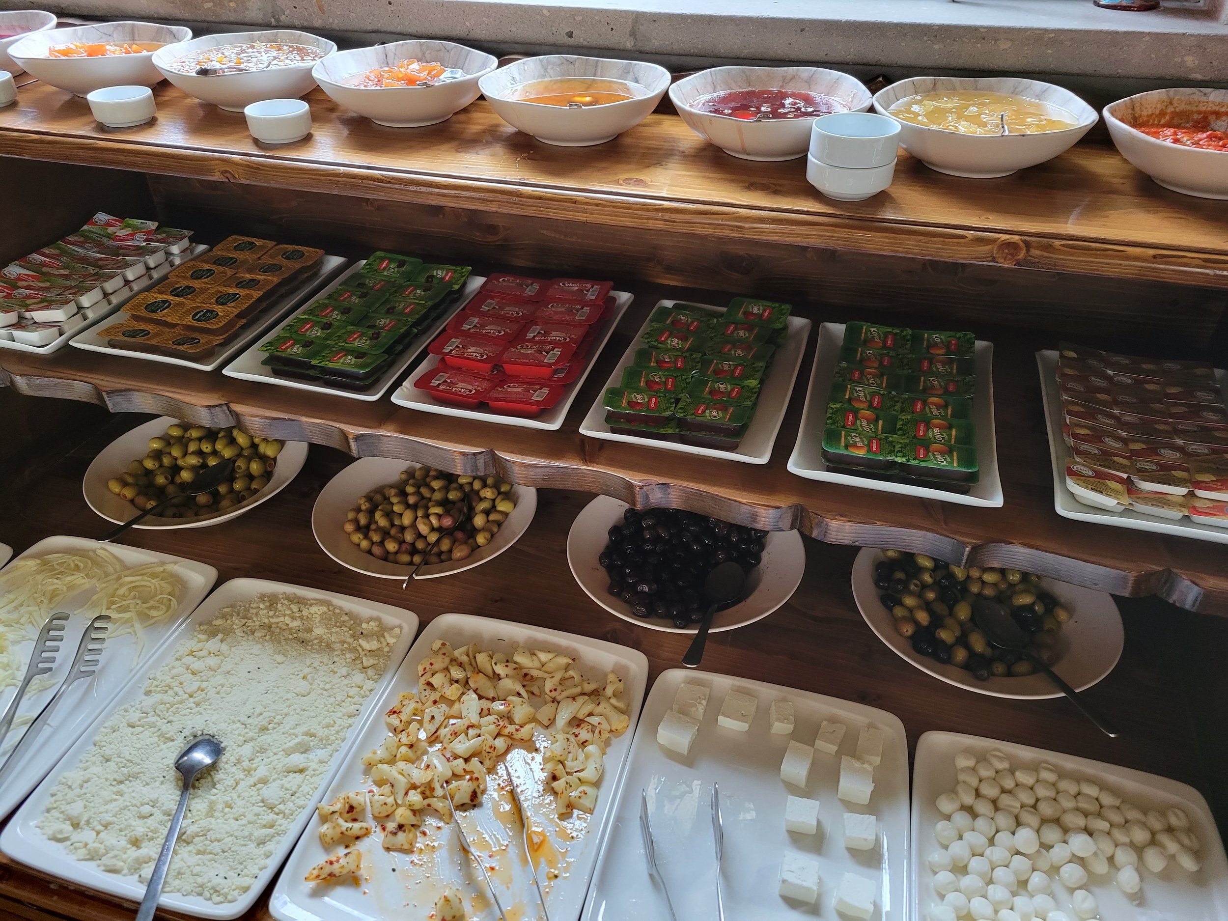
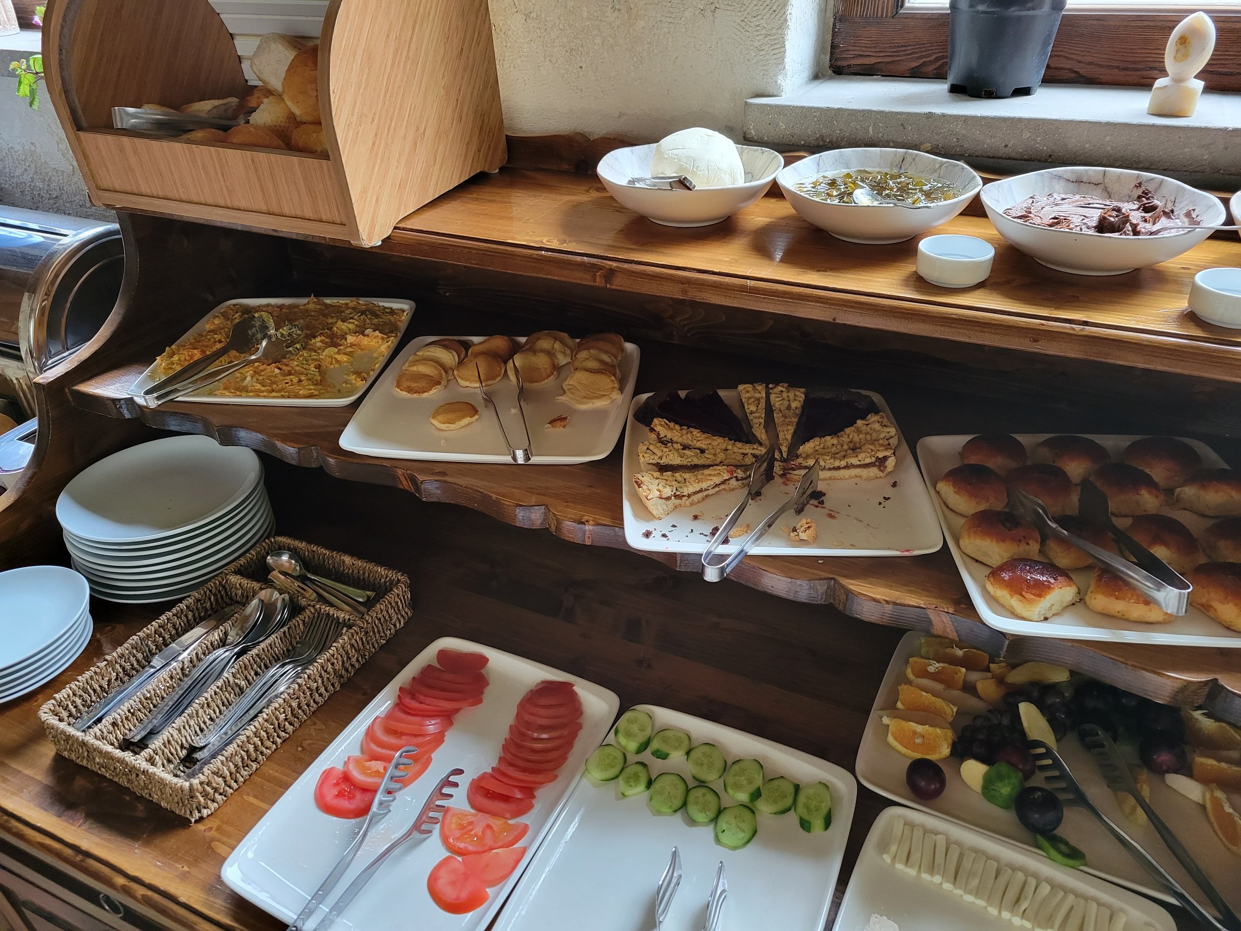
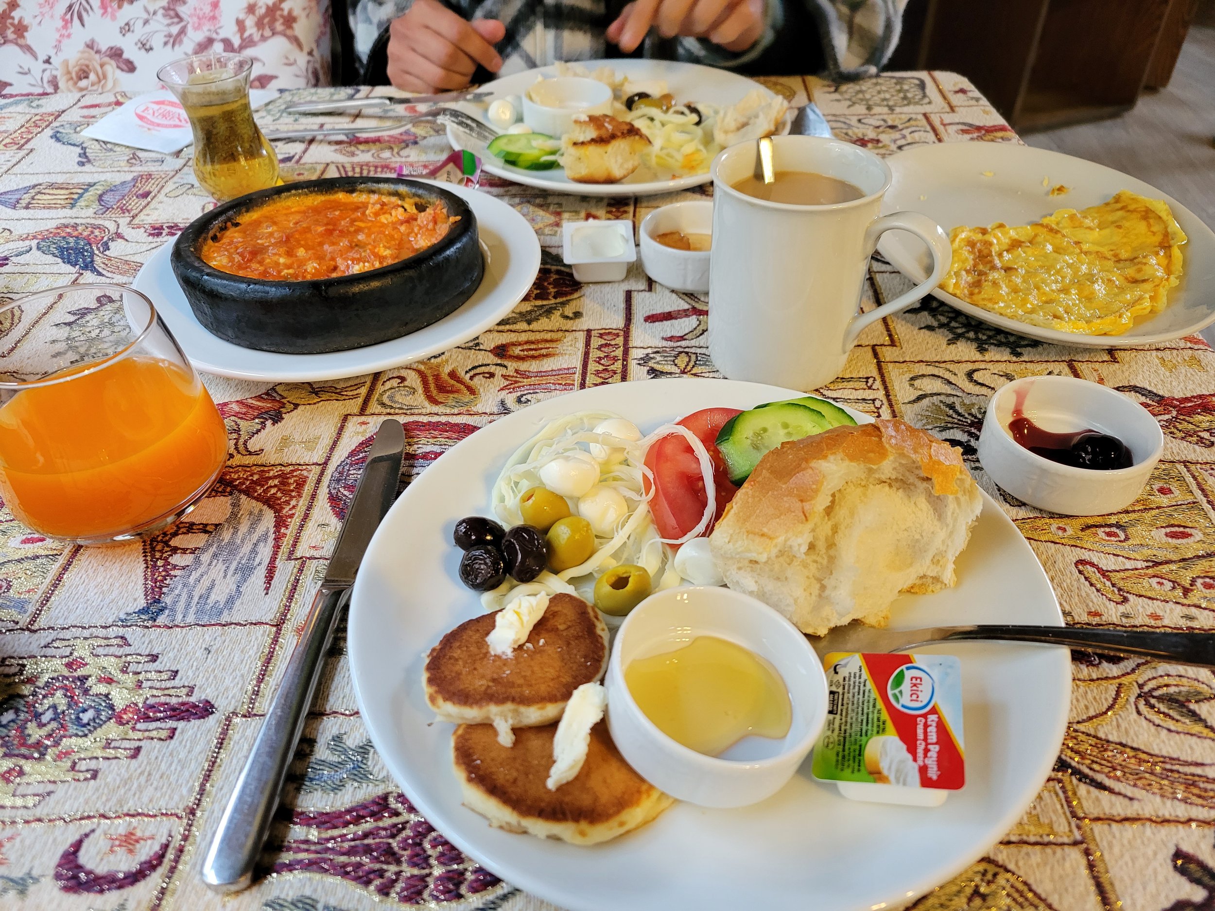
Rested and ready for breakfast at our stay, Hidden Cave Hotel, we began the day with a traditional Turkish breakfast including a wide spread of dishes served in the cafeteria.
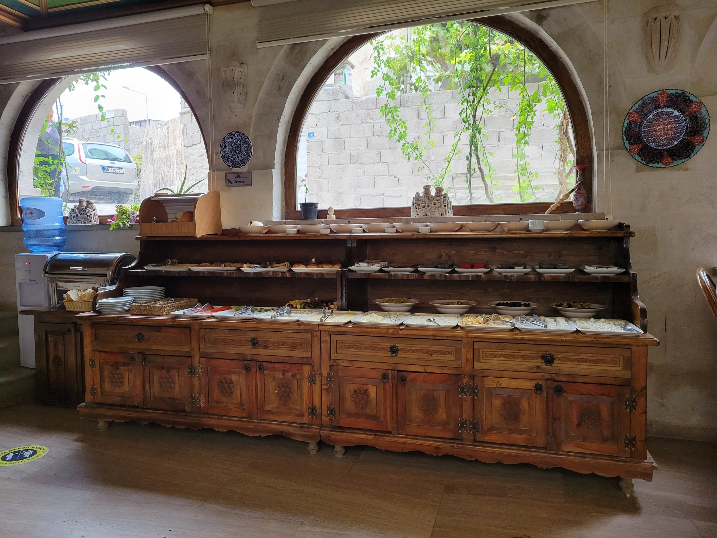
The buffet style meal was laid out across a three tiered display. The options included pancakes, fresh bread, fruit jams and jellies, butter, mild cheeses, olives, sliced veggies, sweets, coffee, tea and fresh fruit juice.
A chef was also on hand to prepare hot dishes like omelettes or menemen. Menemen is a popular traditional Turkish dish made with eggs, tomato, green peppers and spices like ground black and red pepper. It’s cooked in olive oil and depending upon the ingredients can be had as the main dish or included with breakfast. Menemen is particularly delicious when it’s dipped into with crispy French bread.
Around 9:45 a.m. our tour guide arrived for pick up. We loaded into the van and grabbed a handful of others in town along the way. Eventually, we arrived at Pigeon Valley, one of the best spots for taking in the incredible Cappadocia region in Central Anatolia.

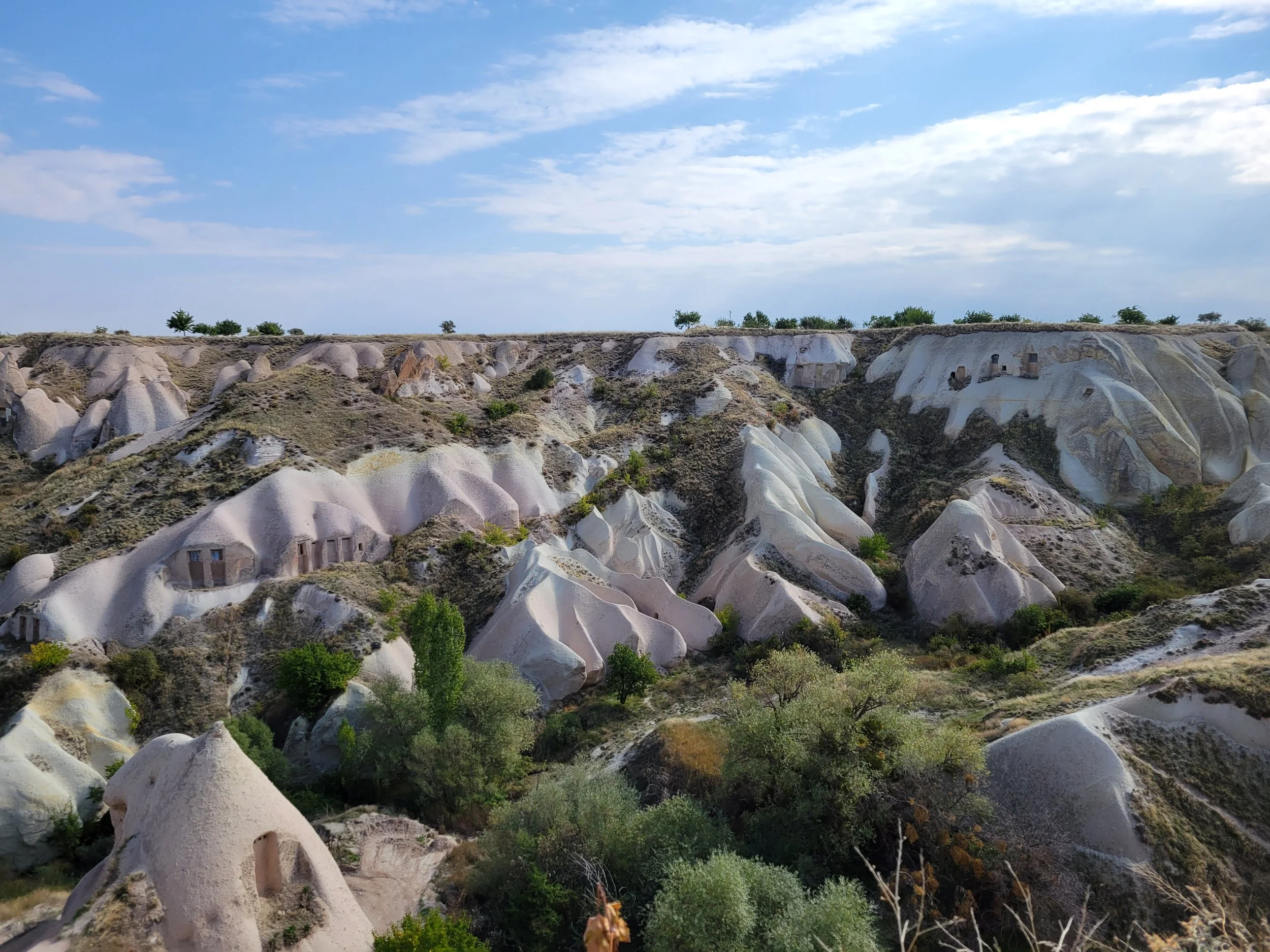
Also known as Guvercinlik Valley, the valley is located between Göreme and Uchisar and is among the most popular hiking trails in Cappadocia, particularly because it stretches between the two. Along the route are abandoned cave dwellings, Christian churches, ancient paintings, earth pillars, and of course, pigeons. Adventurers can also choose to explore the region on horseback, with a jeep safari or from above in a hot air balloon for sunrise.

Pigeon Valley earned its name from the countless manmade dovecotes, or pigeon houses, carved into the soft volcanic tuff. Since ancient times, pigeons have been used in the region for food, as well as fertilizer for the soil. Though, pigeons no longer play such a role, their rocky homes are still maintained by locals and can be found atop rock pillars and inside excavated cave houses and churches, particularly in this valley.

The Evil Eye Tree was an unusual attraction in Pigeon Valley. The tree overlooks the canyon and has dozens of evil eye pendants tied on to its branches. Some say that if visitors buy a pendant from the shop and hang it on the tree, a wish will come true. Evil eyes are also used as a symbol of protection.


The views from our vantage point were absolutely stunning. Nearby, pigeons cooed about, waddling along the dusty ground and every so often, taking flight. At the top of the canyon there’s also a small gift shop selling trinkets to tourists where I picked up a miniature iron with a wooden handle which looked like an authentic artifact.


After Pigeon Valley, our tour stopped at a stone and jewelry outlet to take a look at a local stone that changes color. Zultanite is a gemstone variety of the mineral diaspore and is a color-changing stone mined in the Ilbit Mountains of southwest Turkey. The color of zultanite can vary depending on the light source, appearing yellowish green, light gold, purplish pink, red or reddish brown.
Discover Selime Monastery
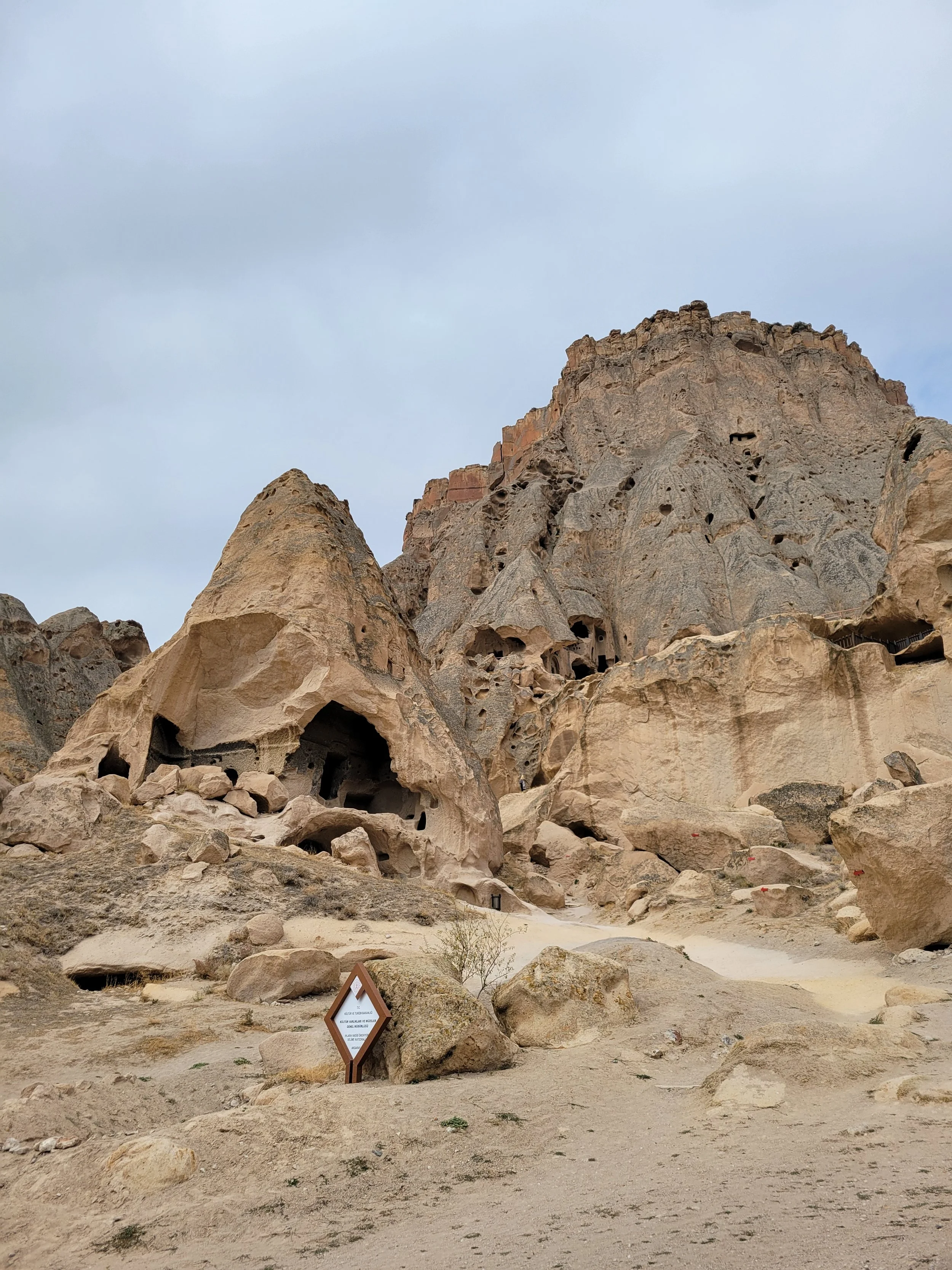
Our next stop was Selime Cathedral located in the Ihlara Valley an hour away. Selime Cathedral is the largest and most elaborate cave complex in Cappadocia. It’s also home to the largest religious structure in the region with a cathedral-sized church cut directly into volcanic rock.


The multi-level Byzantine settlement includes dozens of rooms connected via tunnels and passages with an enormous kitchen, two halls, a basilica church and additional rooms such as a wine cellar, stable and monks living quarters, all sculpted around two courtyards. The massive size and prime location indicate the importance of Selime Castle, serving as a significant center for religious activities for Christians during the Byzantium period.

From below, the complex didn’t look particularly impressive but as we climbed to reach its entrance, the structure began to unfold, becoming increasingly obvious as to why it’s so historically significant. The monastery is said to date back to the 8th or 9th century BC, the upper section mildly resembling a fortress with well-preserved walls and trenches, as well as steep rocky staircases and hidden passageways.


Carved directly into the mountainside, the monastery was converted into a caravanserai, a refuge for travelers and tradesmen journeying along the silk road, in the 10th or 11th century. This idea was introduced by the Seljuk Turks to encourage trade on this ancient road until faster sea routes were discovered. The monastery has remained abandoned since the 16th century.

Today, the site is an official museum that requires an entrance fee. Climbing the steep hill up to the main opening in the rock, we entered and began exploring. The basilica church, or Cathedral, in the upper courtyard is not only one of Cappadocia’s largest but also most articulated churches. The church is separated into three sections by two rock columns and its wall paintings date to the 10th or 11th century.

Inside the complex, original frescoes still adorn the walls although some have been damaged by weather. And signs of several early civilizations are present including Hittites, Persians, Romans, early Christians, Byzantines, Seljuk Turks and Ottomans. Interestingly, Selime Castle did not sit alone in the valley and was more like the centerpiece of a larger settlement. Many other dwellings including mansions and cave churches honeycomb the surrounding cliffs.

About 300 feet above Selime Castle, a fortress once stood at the top of the plateau. And a 650 foot long defensive wall with a central gate, four round towers and mote closed off the end of the plateau. Many locals even claim that a long, steep tunnel leads from Selime Castle to the upper bluff.
Additionally, five massive rock-cut courtyard mansions are located about a mile southwest of the castle. They lie across the river on the eastern edge of Yaprakhisar village at the base of the cliff. Today, local villagers use the unprotected Byzantine mansions for agricultural storage, either altering or securing many of the rooms.


The complex sits high on a cliff face 165 feet above the Menderes River. This prime location is both easily defensible and offers a commanding view across the valley. Upon arrival, visitors would leave their horses at the base of the cliff in the stables just left of the path. Then, they’d ascend the hill through a long, curved tunnel. This entry created security and status for the complex.

From the first landing area, a steep tunnel staircase leads into the lower courtyard. This first courtyard contains the main living areas such as the kitchen, bathing room and first hall. Farther east and slightly higher the second courtyard is home to the more decorated hall and churches and likely would have had a defensive wall. The the inhabitants’ social hierarchy was reinforced through the various levels, detailed frescoes and commanding views of the castle.

The double courtyard complex extends over 300 feet across the cliff face. And although the interiors are elaborate, the exterior lacks any cohesive overall design or facade. The site likely developed over time with inhabitants adding rooms as means became available.


The large room to the left of the courtyard was a kitchen with a decorated facade, as is normal for Cappadocian kitchens. Cooks used mushroom shaped ovens to bake bread on the upper shelf, while large pits in the floor supported massive iron pots. As fire roared inside the pit, a tunnel on the side provided the fire with oxygen and allowed a cook to stoke the coals. The tall arched ceiling had a central chimney leading to the roof, allowing smoke to exit the room.


Rows of dome shaped niches and several other larger niches were used as shelving to hold goods. The spacious kitchen is roughly 26 feet wide and long, indicating a large population lived at the complex. The kitchen is also far removed from the living spaces and churches, typical of Cappadocian settlements.

Various utility rooms extend from the rear wall with a pit room used for weaving textiles located behind the kitchen. There, a weaver would sit against the wall with their feet in the rectangular pit, while post holes around the pit supported the loom’s wooden frame.


Leaving the kitchen, we moved out into the open air and through the castle room by room. Next, we’d discover the first hall, described as a Monastery.


Selime Castle has two main halls connected by a narrow tunnel, once divided by a thin rolling rock. The first hall sits directly in front of the tunnel entrance.


The hall has a flat ceiling and a unique two level design. The lower portion has six arched alcoves, each with an arched niche and bench. The upper level arcade opens to a wrap around gallery, reached by a staircase in the back corner. The upper arcade is made of thick horseshoe shaped arches, while the left side has a low protective barrier.
One can imagine this gallery coming to life during a community gathering. The great size, abundance of arches and the network of passageways show what social activity might have occurred in such a space. After the tenth century, the hall was repurposed with users carving several pits and animal troughs.


The second barrel vaulted hall has massive proportions at 55 feet deep, 20 feet wide and 26 feet high. This was the main hall used for receiving visitors and hosting ceremonial meals. A step divides the long hall, both visually and socially, into two sections. The upper portion was reserved for the highest members of the community and retains a blind arcade on thick pilasters, copying the style of the other hall. The entire hall was plastered, with several layers on the upper portion and the ceiling had turned black from later cooking pits. The high arched window and large door allow generous amounts of light into the space.


At the back of the hall is a cross shaped room with a cross carved into the ceiling. The room, with a private toilet in the tunnel, had large swinging doors allowing the head of the household both privacy for eating and sleeping and a dignified entrance into the main hall. The hall’s exterior porch extends forward nearly 10 feet and a “fake” door lintel and ornate carving mark the formal space.

Lastly, was a visit to the church, or Cathedral, in the upper courtyard. Its architectural design indicates great skill and planning. The basilica style church has two arcades dividing three aisles. The pillars alternate between square piers and round columns, where each pillar features a monumental base and capital. The apses (semicircular recess) above hold a window. Above the arcades, a barrel vaulted ceiling rises over the moldings and side aisles contain blind arches, terminating into the apses.
The central aisle has smooth plaster with painted images, though they are in poor condition and only faint outlines remain. Patterns in diamonds and spades follow architectural elements on each wall. Scenes from the lives of Jesus and Mary fill the upper registers on the ceiling, while each soffit has five saints in roundels, circular shaped decorative elements.

The church has several unique features that appear in tenth century Georgian churches but nowhere else in Cappadocia. Those include a throne chair cut into a pillar, alternating pillar designs and the donor scene above the door. Though that image is faint and damaged by smoke, it’s possible to make out the Virgin Mary, whose hands extend to bless figures on each side. Her hands resting on their heads is a symbol often found in imperial images and their clothing confirms their noble stature.
“Do not be misled by the desire for wealth; the love of money has destroyed many, for this flesh is earth and clay.”
An inscription is painted on the molding above a niched grave to the left of the entrance. The Greek funerary poem warms people about the dangers of money. Such sayings often appear near Byzantine graves.

Next to the church is a single fairy chimney with three adorned rooms. The lower room, mislabeled Chapel, has two bird-like creatures looking at a central pillar. In the uppermost room, the ceiling contains registers of blind arcades that lean into the ribbed domes. These areas were used for living and sleeping.
Apart from serving religious purposes, Selime Cathedral was also a military base. Locals used the cathedral as a castle throughout history and defended themselves by building trenches and fortifications at various points. Many religious figures were also educated in the cathedral and its surrounding areas in the northern entrance of Ihlara Valley. The area was among the most important locations for Orthodox Christians during the Byzantine period. Thanks to the tolerance by the Seljuk Turks who reigned the area since the 11th century, the religious life in Selime and Ihlara Valley continued for ages.
Hike the Dramatic Ihlara Valley
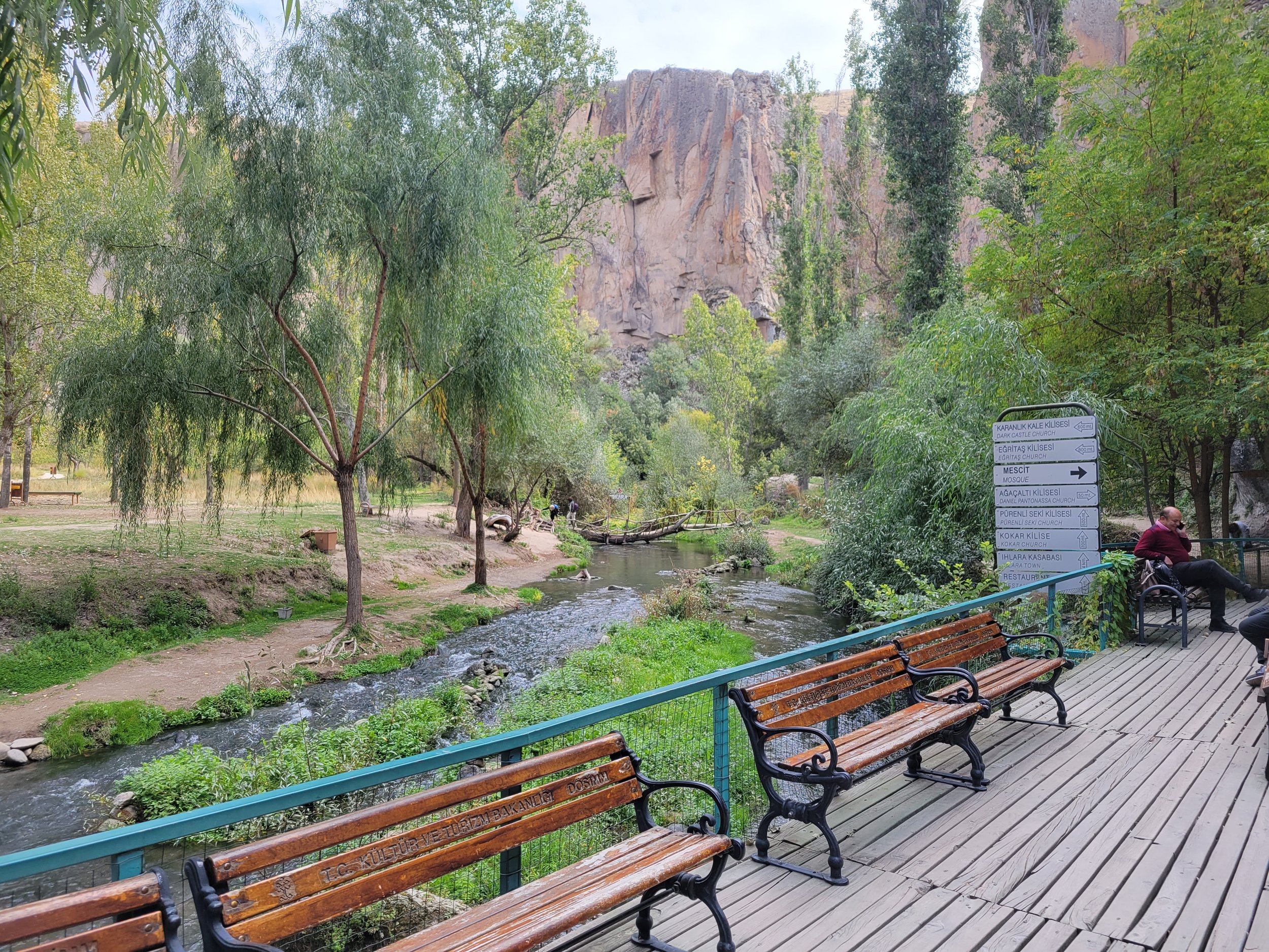
A short 10 minute drive from Selime Cathedral lies the dramatic Ihlara Valley gorge. Coined the Grand Canyon of Cappadocia, the Ihlara Valley sits between Mount Hasan and Mount Melendiz. Almost nine miles long and cut by a small stream, the Melendiz Suyu, over thousands of years through the volcanic Cappadocian landscape, the valley is home to nearly 60 Byzantine churches, chapels, monasteries and hermit caves dating from the 11th to the 13th centuries. These rock carved structures came to be by the hands of monks and hermits who carved homes and churches directly into the rock along the valley’s vertical surfaces.


Taking in the first view of the gorge was incredible, though, for someone who’s been to the Grand Canyon, it doesn’t quite compare. The rocky sides of the canyon shoot straight up hundreds of feet, close to 500 feet in some areas, with sharp crevasses splintering the rock walls and thick green plant life filling the valley.

At the north end of the village of Ihlara, a set of stairs with almost 400 steps, descends more than 300 feet down into the canyon, beginning the hike within its steep walls. The typical trail last 6.3 miles and is considered a moderately challenging route, though, personally it felt fairly easy, taking a few hours to complete.


Once called Peristrema, the valley follows a slow and steady stream, allowing for a clam and beautiful hike. During the trek, we soaked in the surrounding nature and gazed upward at the ancient dwellings high above in the mountainside. From the 7th century AD, the valley was settled by Byzantine monks who carved their houses and churches out of the tuff stone (rock made of volcanic ash), which was left by eruptions of Mount Hasan.

Paired with the rock dwellings were dozens of ancient pigeon houses carved into the rocks, sometimes creating beautiful dot-like patterns above. Historically, pigeons have served several functions in this region. Of course, their droppings were used as fertilizer for crops but they also acted as messengers for communication and their egg shells were crushed and mixed to make plaster for the cave walls.

Of the Christian churches in the valley, there are two groups. The first are churches near the village of Ihlara, covered with murals of a local Cappadocian type showing an influence from Persia and Syria. They mostly pre-date the Iconoclasm, a social belief in the importance of destructing icons and other imagery or monuments, frequently for religious or political reasons, but were often repainted in newer styles over time. The second are those located near the village of Belisarma and consist of churches in the Byzantine style of the 10th and 11th centuries, known as Macedonian art.
During the trek, it was pleasant to be surrounded by such lush greenery in the valley, shooting up alongside the river. Cappadocia only seems to support trees and shrubs deep within valleys where water tends to pool. Along the riverbed were olive and poplar trees, as well as green mosses and other plant life.


Late in the day, we reached an adorable restaurant partially floating in the river and were all more than famished and ready for whatever awaited. For our meal we selected the et güveç, a meat casserole with bulgur and veggies, a hearty dish served in a clay baking dish. We were also served Turkish red lentil soup, salad and pomegranate orange juice. Dessert was a handful of fresh mandarin oranges.


After filling up on Turkish fare, we returned to the trail. The trail, popular for bird watching, walking and hiking is open year round and is gorgeous anytime of the year. The walk is mostly flat unless you intend on reaching any of the churches of which the Church Under the Tree, Ağaçaltı Kilisesi, is home to some of the most well preserved frescoes in the area, dating to the 7th century AD.

Trekking the valley, it’s best to start early in the day to avoid the heat and crowds, and also bring along water, sunscreen and cash. Guests on horses may also be encountered. The path tends to be much quieter near the tall staircase toward Ihlara and a bit busier near Belisirma, which leads out of the canyon with a quiet stroll. Belisirma tends to be more crowded due to the cafes and tourist shops that attract visitors. Personally, I much preferred the way we entered, ending up at the cafe for a bite to eat and a rest toward the end of the hike.
Explore the Ancient Kaymakli Underground City
Emerging from the valley, our group drove an hour northeast to a remarkable underground city called Kaymakli Yeralti Sehri. One of several underground complexes found throughout Cappadocia, Kaymakli Underground City is part of the citadel, or stronghold, of Kaymakli in the Central Anatolia Region of Turkey. It’s a network of underground tunnels and chambers meant to protect its inhabitants from attack and persecution, specifically designed to prevent enemies from moving about quickly and easily.
With an ancient name of Enegup, the caves may have first been built in the soft volcanic rock by the Phrygians, an Indo-European people, in the 8th-7th centuries BC. When their language died out in Roman times it was replaced by Greek and its inhabitants converted to Christianity creating a culture often referred to as Cappadocian Greek. The group expanded the caverns by adding chapels and Greek inscriptions.

The city vastly expanded and deepened during the Eastern Roman era while it was used as refuge from Muslim Arab raids during four centuries of Arab-Byzantine wars during 780 to 1180. The city is also connected to Derinkuyu Underground City, the largest excavated underground city in Turkey, through miles of tunnels. Artifacts discovered in these settlements date to the Middle Byzantine Period between the 5th and 10th centuries AD. During the Mongolian attacks of Timur in the 14th century, a Turco-Mongol conqueror who founded the Timurid Empire in and around modern-day Afghanistan, Iran and Central Asia, these cities continued to be used by Christian inhabitants for refuge.

After the region was defeated by the Seljuk Turks of Persia, the cities were used as sanctuaries from the Turkish Muslims. Even as late as the 20th century, the inhabitants now called Rûm (Eastern Romans) by their Ottoman Turkish rulers, were using the underground cities to hide from Ottoman oppression.
Ultimately, when the Christian Rûm inhabitants of the region were expelled in 1923 in the population exchange between Greece and Turkey, the tunnels were abandoned. The 1923 Greek-Turkish population exchange forcibly relocated one and a half million people and was a landmark event that set precedent for population management based on religious or ethnic difference. As a result, Muslims in Greece were resettled in Turkey and Greek Orthodox Christians in Turkey were moved to Greece.

The intricate system of tunnels, chambers and galleries has been excavated deep into the volcanic tuff rock at Kaymakli Underground City. In total, there are eight floors, although only four are open to the general public today. The underground city can hold up to 3,000 people and has a depth of over 275 feet.


First opened to tourists in 1964, only a fraction of the complex is accessible to visitors. With nearly 100 tunnels in the underground city, many are still in use today for storage, stables and cellars. As such, houses in the surrounding village have been built around the tunnels. The underground city at Kaymakli differs from that of Derinkuyu in terms of layout and structure, with lower, narrower and steeper tunnels. Of the four levels open to guests at Laymakli, each area is organized around ventilation shafts, making them dependent on upon its availability.


On the first level is a small stable, its size possibly indicating others in the area. To the left of the stable is a passage with a stone door leading to a church. On the right of the stables are several rooms, perhaps living spaces. Located on the second level is a church with a nave (central part of a church) and two apses (vault or semi-dome). In front of the apses, a baptismal font sits with seating along the walls. This level also contains living spaces.


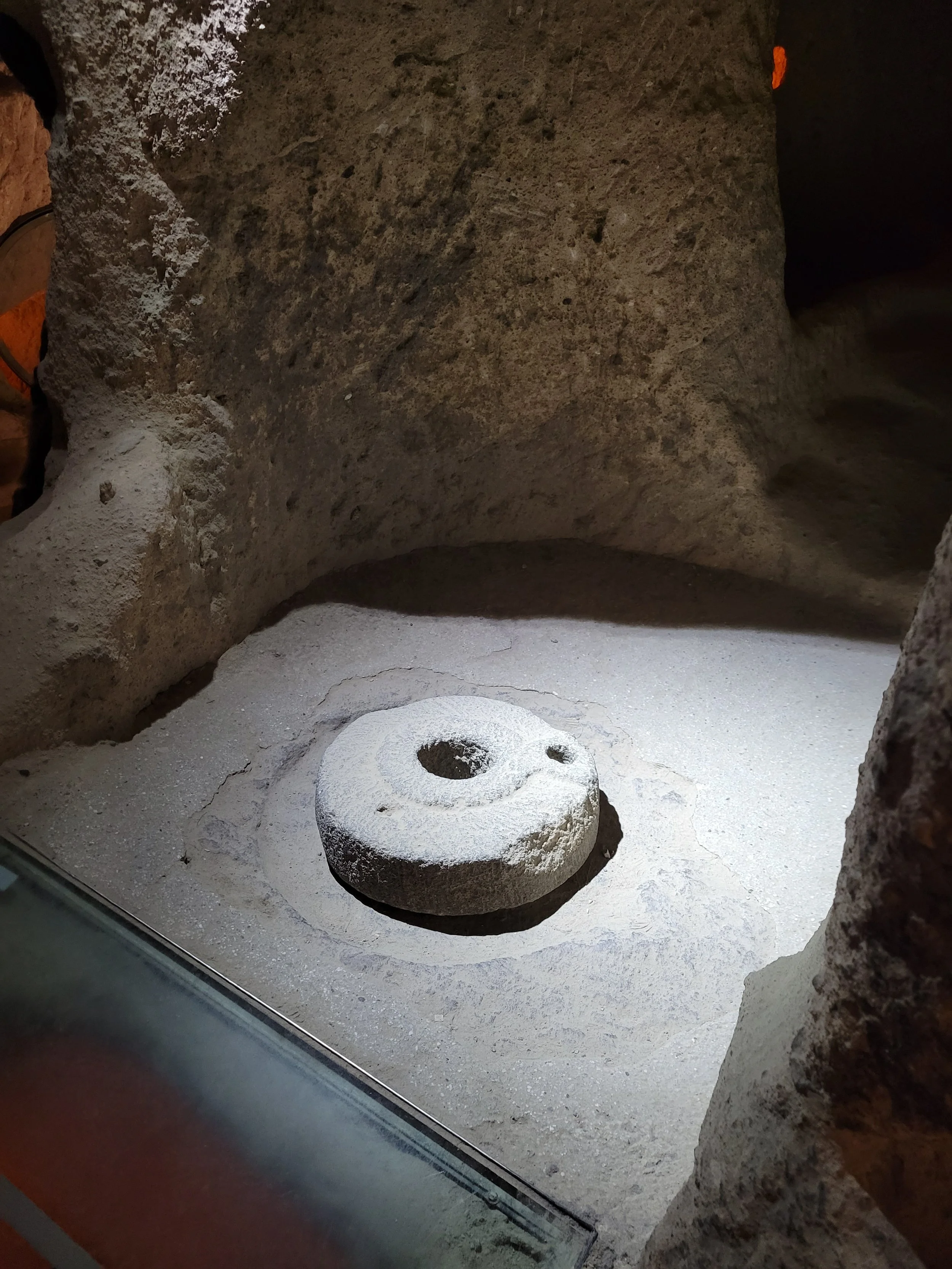
The third level is one of the most important areas of the underground compound, home to kitchens, storage areas and wine or oil presses. There’s also a block of andesite, a volcanic rock that’s usually gray to black in color, with relief textures. The stone was used for cold-forming copper and has 57 holes carved into it.
As one of the largest underground settlements in the region, the sheer amount of space dedicated to storage indicates the need to support a large population. Additionally, the large quantity of storage rooms and areas used for earthenware jars on the fourth level indicate some economic stability.

Exploring the dimly lit tunnels was quiet surreal, though, I couldn’t possibly imagine living below the earth in such cold dark caves. Deep inside the tunnels it felt eerily calm but also far removed from the comforts of everyday life, particularly sunlight and nature. Our guide noted that those with claustrophobia might want to use caution but I didn’t find the tunnels we traversed particularly tight but more so that the ceilings and arcgways were very low.
Enjoy Sweet Treats & Atay Panorama
Nearing the end of our tour, we stopped at a local candy shop to check out all kinds of Turkish sweets. Overwhelmed and not sure what to focus on, I roamed about the store, sampling as many sweets as possible.


The most common sweet treat is the Turkish delight, or lokum, a family of confections based on a gel of starch and sugar. The best varieties include dates, pistachios, hazelnuts or walnuts bound by gel, while traditional varieties are flavored with rosewater, pomegranate, bergamot, orange or lemon. Other types of Turkish treats include baklava, walnut churchkhela and marzipan, or finely ground almonds, powdered sugar and water, blended and baked.

During our visit, I picked up a few bags of local tea, toasted pistachios and a spice known as sumac. I also tried to buy honey since I’d heard Turkish honey is quite special but they didn’t offer small sizes.

The last stop of the day was a gorgeous viewpoint just before sunset. Atay Panorama, near Göreme Panoramic viewpoint, is one similar to our visit first thing this morning. Views of Pigeon Valley spread across the landscape as far as the eye could see.


Fairy chimneys rose up out of the valley and a wooden chair sat just at the edge of the hill, if you dared to take a seat, though our guide warned against it.

This stunning viewpoint is often used to witness hot air balloons during sunrise. Early in the morning, if there’s good weather, they dot the sky in dozens.


Tired and pleased with another amazing day in Cappadocia, we made our way back to town and were dropped at our hotel for the evening.


